Categories of Zoning
Zoning categorizes land within a municipality or city into different zones or districts based on specific land use classifications. The exact categories in zoning can vary between jurisdictions, but here are some common categories found in zoning: Residential Zones, Commercial, Industrial, Mixed-Use, Agricultural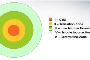
Concentric Zone Model Theory and Its Limitations
This zone is identified by both area wise and population wise. Area wise it is in Limbo (means it is in uncertain condition or transition phase or keeps on changing). Immediately adjacent to the CBD, it is an area that may be slated for expansion if the business is good. In this zone land and properties are held for speculation purposes. Characterized by mixed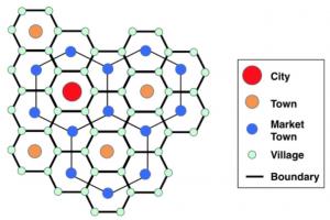
Chrystaller Central Place Theory - Definition and Principles
Chrystaller Central Place Theory: Theory was first proposed in the 1930s by German geographer Walter Chrystaller, based on his studies of southern Germany. August Losch in Germany and Brian Berry and others in the U.S further developed concepts during the 1950s. The theory applies most clearly in regions such as the Great Plains, which are neither heavily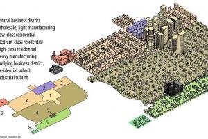
Multiple Nuclei Model in Urban and Regional Planning
It says even though a city may have begun with a CBD, it will have other smaller CBDs develop on the outskirts of the city If other CBDs develop on the outskirts of a city they would be around valuable housing areas to allow shorter commutes to the outskirts of the city. The number of nuclei around which the city expands depends upon situational as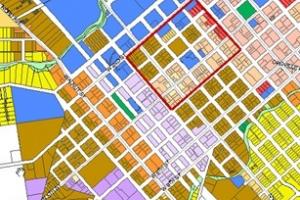
What is Zoning in Urban Town Planning
Zoning has been adopted by most of the countries of the world such as Germany, England, America, Russia, Japan, Pakistan etc. In 1916 first zoning in New York was carried out. The land which is developed without any motive of making profit It includes roads, parks, playgrounds, educational buildings, government offices. The main non profit making use in urban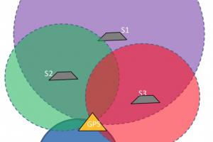
GPS Constellation and Characteristics of GPS Constellation
A GPS receiver calculates its position by precisely timing the signals sent by GPS satellites. The receiver uses the messages it receives to determine the transit time of each message and computes the distance to each satellite. The GPS receiver with the help of the satellites determine: Time (t) Longitude(x) Latitude(y) Altitude (z)
Principles of Zoning in Urban Town Planning
It is the distribution or division of land (in town planning) into particular zones based upon some criteria or principles. The principles of zoning include the following elements which are given importance while zoning an area. Concentric growth: The growth of buildings which spread from a center in all directions is called concentric growth. These types of buildings
Land Use Pattern | Basic Urban Form Conceptual Frameworks
resembles the Dispersed Sheet urban form of Kevin Lynch, which he described as having “maximum flexibility, personal comfort, independence and where local participation is highly possible”. Trend extension is the result of individuals building anywhere according to their own preferences and convenience with minimal government intervention.
Sources of Errors in GPS and their Correction
Slight inaccuracies in time keeping by the satellites can cause errors in calculating positions. Satellites drift slightly from their predicted orbits which contributes to errors. Let the GPS receiver receive signals from 4 satellites, then there are two cases: The satellites are at 90° to each other w.r.t the GPS receiver. For demonstration purpose we will take 2 satellites
Masterplan of City - Baku, Azerbaijan
A Master Plan is a general plan for the future layout of a city showing either the existing and proposed streets or roads; open spaces public buildings, etc. A city is historically established and the most rational and sustainable form of human settlement. Owing to objective regularities of regional town planning, cities have repeatedly been rebuilt, changing their
Problems of Urban Sprawl
Land use pressures are particularly mounting on the edges of the urban areas; much of the land resources and capital lies in private hands. This puts a heavy responsibility on public bodies to maintain the balance between urban development and conservation needs. Urban planners do not seem to realize that class I and class II agricultural soils are a scarce andUrban Problems and Challenges
Excessive size both in population and geographical area Where the economic base of the cities is inadequate to cope with problems created by excessive size Tremendous amount of land being gobbled up by sprawl of cites, especially giant conurbation. The loss of agriculture land to urban/industrial sprawl is of grave concern. Once loss this prime land cannot be replaced.Characteristics of Planning
There are six characteristics of planning which are of prime importance: The use of available resources as economical as possible, so as to achieve the greater possible measures of improvement within limited resources. Sustainability means that there should be a balance between people and resources. Use of resources in such a way that the environment should not
Integration of GPS and GIS for use in Urban Planning
GPS are becoming very effective tools for GIS data capture. The GIS user community benefits from the use of GPS for location data capture in various GIS applications. The GPS can easily be linked to a laptop computer in the field, and with appropriate software. Thus GPS can help in several aspects of construction of accurate and timely GIS databases. GIS is about