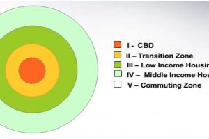
Concentric Zone Model Theory and Its Limitations

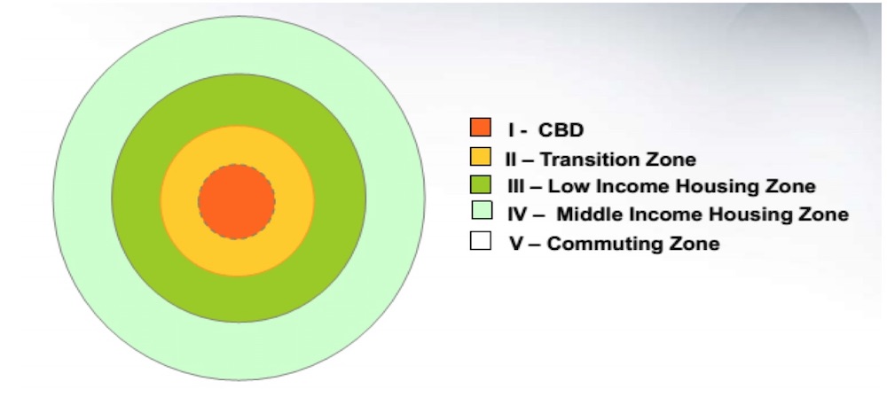
The Concentric Zone Model is a theory proposed by sociologist Ernest Burgess in 1925 as a way to understand the spatial organization and land use patterns within cities. The model suggests that urban areas can be divided into a series of concentric rings or zones, each characterized by distinct land uses and socio-economic characteristics. The model provides a simplified framework for analyzing urban structure and the distribution of population and activities within a city.
- Concentric Zone Model Theory was created by sociologist EW Burgess in 1925
- Based on a study of land use patterns and social groups in Chicago
- The city grows outward beginning with the CBD
- Similar & functionally related activities will locate at the same distance from CBD
- The formation of zones is based on accessibility in distance to the city center
- The city is divided into 5 concentric zones:
Zone I:
Central Business District (CBD) Zone I, also known as the Central Business District (CBD), is characterized by intense commercial activities, high-density development, and a concentration of business, financial, and administrative functions. It is the heart of the city and typically features tall buildings, corporate offices, government institutions, hotels, shopping centers, and entertainment facilities. The CBD is a hub of economic and social activities, attracting a large number of people during business hours. Examples:
- Wall Street in New York City, USA: Known for its concentration of financial institutions, banks, and corporate offices.
- Canary Wharf in London, UK: A major business district with tall office buildings and headquarters of many global financial companies.
- La Défense in Paris, France: A prominent business district featuring modern office towers, shopping centers, and multinational corporations.
Zone II:
Zone of Transition Zone II, known as the Zone of Transition, is an area surrounding the CBD that experiences a mix of land uses and a gradual transition between commercial and residential activities. This zone is characterized by a dynamic and evolving land use pattern, with a tendency for land uses to change over time. It may feature a combination of commercial establishments, small-scale industries, warehouses, and residential areas undergoing gentrification or conversion into other land uses. Examples:
- Brooklyn in New York City, USA: A neighborhood experiencing gentrification with a mix of industrial warehouses, artist studios, and residential conversions.
- Shoreditch in London, UK: A formerly industrial area that has transformed into a creative hub with a mix of galleries, tech startups, and residential lofts.
- Poblenou in Barcelona, Spain: A district undergoing urban renewal, transitioning from industrial zones to mixed-use developments, including office spaces and residential buildings.
Zone III:
Lower Income Working People Zone III is primarily occupied by lower-income working people. It consists of residential areas with a high concentration of affordable housing, often including slums or informal settlements. These areas typically provide housing options for lower-income groups, including laborers, workers, and their families. Basic amenities and services may be limited in this zone. Examples:
- Dharavi in Mumbai, India: One of the largest slum areas in Asia, providing housing for low-income workers in industries like textiles and recycling.
- Favelas in Rio de Janeiro, Brazil: Informal settlements where lower-income residents live in self-built homes with limited access to infrastructure and services.
- Kibera in Nairobi, Kenya: A large slum with crowded living conditions, primarily occupied by low-income workers and informal economy activities.
Zone IV:
High-Income Residences Zone IV is characterized by high-income residences, catering to white-collar professionals and middle-class families. It includes upscale residential neighborhoods, gated communities, and housing developments that offer a higher standard of living. These areas often have well-maintained infrastructure, recreational facilities, and a range of amenities and services to cater to the needs of affluent residents. Examples:
- Beverly Hills in Los Angeles, USA: An affluent residential neighborhood known for its luxury homes, gated communities, and high-end shopping districts.
- Knightsbridge in London, UK: A prestigious residential area with upscale townhouses, exclusive shops, and affluent residents.
- Shibuya-ku in Tokyo, Japan: A district featuring high-end residential buildings, luxury condominiums, and upscale amenities catering to affluent residents.
Zone V:
Commuter Zone Zone V, also known as the Commuter Zone, comprises areas that are located on the outskirts of the city and are primarily residential in nature. These areas are inhabited by people who commute to the central city or other employment centers for work. They offer a balance between residential living and proximity to urban amenities, with a focus on providing housing for commuters. Commuter zones may include suburban neighborhoods, satellite towns, or residential areas connected to the city through transportation networks. Examples:
- Suburbs surrounding major cities, such as:
- Suburban areas around New York City, USA, such as Westchester County and Long Island.
- Suburbs surrounding London, UK, such as Richmond or Wimbledon.
- Satellite towns near Tokyo, Japan, such as Chiba or Saitama, where residents commute to the city for work while enjoying a more residential and suburban lifestyle.
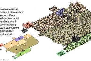
Zones in the Concentric Zone Model Theory
Central Business District
- Social and civic life of city is found in this zone.
- It contains shopping areas, hotels, office buildings, banks, theatres, wholesale centers, and other businesses.
- These are the uses which seek central location for their success and utility.
- Public uses should be equidistant from the surrounding areas
- It also contains, in short, the economic, political, and cultural life of the city.
- City parks, marriage halls, higher-order education facilities, and hospitals are also located in the center.
- Uses along the boundary of this zone are the wholesale markets, warehouses, and industry which don't require much area.
Zone of Transition
- Characterized by a mixed pattern of industrial and residential land use
- This zone is identified by both area wise and population wise. Area wise it is in Limbo (which means it is in uncertain condition or transition phase or keeps on changing).
- Immediately adjacent to the CBD, it is an area that may be slated for expansion if the business is good. In this zone land and properties are held for speculation purposes.
- It inherits instability and attracts population which is similarly in transition. Further, it can also be identified by the variety and changing character of land uses.
- The residential area also starts from this zone. Other identifying features of this zone are the old structures, apartments (multi-storey buildings), residential slums, and shabby homes.
Lower Income Working People's Zone
- Lower-status residential area
- The "workingmen quarters"
- Solid blue-collar, located close to factories of zones 1 and 2
- More stable than the transition zone around the CBD
- Often characterized by ethnic neighborhoods
- Spreading outward because of pressure from transition zone and because blue-collar workers demanded better housing
High Income Residences
- It contains large residential area of city. It is also called a high-class residential zone in the Concentric Zone Model Theory
- Well-decorated, undivided, and costly constructed high-class residences are found in this zone.
- Further detached houses and apartment buildings with high-quality infrastructure and community facilities are included in this zone.
- In most cases, this zone may be the most accessible area from all parts of the city
Commuters' Zone
- Burgess dealt fully with this fifth zone. In this zone, all the suburban communities found along the arteries of transportation.
- As growth occurs, each inner zone of the generalized diagram tends to invade the next outer zone.
- Sociologist says it is a process of invasion-succession. And the rate of progression of this tendency depends on economic expansion in the city and the rate of population growth.
Limitations of The Concentric Zone Model
Here are some of the key limitations of the Concentric Zone Model:
-
Inapplicability to Contemporary Cities: The Concentric Zone Model was developed based on observations of early 20th-century American cities, which had a different urban structure and demographics compared to today's cities. Modern cities are more diverse, complex, and varied in their spatial organization, making the model less applicable in contemporary urban contexts.
-
Oversimplification of Urban Structure: The model oversimplifies the complexity of urban spatial patterns by representing cities as a series of concentric rings. In reality, urban areas often exhibit more irregular and fragmented patterns, influenced by topography, historical development, transportation networks, and other factors that can create multiple centers of activity and different patterns of land use.
-
Neglect of Social and Economic Factors: The Concentric Zone Model primarily focuses on the physical organization of land uses and neglects the social and economic factors that shape urban development. It does not account for variations in income, social class, ethnic composition, or other socio-economic factors that influence the spatial distribution of population and land uses in cities.
-
Limited Consideration of Neighborhood Change: The model assumes a stable and static urban structure over time, with little consideration for the dynamics of neighborhood change. It does not adequately capture the processes of gentrification, urban decay, or the transformation of neighborhoods, which are crucial aspects of urban development and can lead to changes in land use patterns.
-
Lack of Spatial Heterogeneity: The model assumes a uniformity of land uses within each zone, overlooking the spatial heterogeneity that exists within zones. In reality, there can be variations in land use intensity, building types, and socio-economic characteristics within a single zone, challenging the homogeneous depiction of each zone in the model.
-
Limited Application to Non-Western Cities: The Concentric Zone Model was developed based on observations of Western cities and may not fully capture the unique characteristics and spatial organization of non-Western cities, which often have different cultural, historical, and socio-economic contexts.
Despite these limitations, the Concentric Zone Model played a significant role in shaping urban sociology and provided a foundation for further research and understanding of urban structure and processes. However, it is important to recognize its shortcomings and complement it with other models and theories to gain a comprehensive understanding of contemporary urban dynamics.
- Too simple and Static
- Limited in historical and cultural applications.
- It is a product of its time. (1950s)
- The model was developed for American cities and has limited applicability elsewhere.
- Ignorance of the process of redevelopment