Working Mechanism and Components of GPS

Space segment:
- Composed of satellites that transmit signals from space, on the basis of which time and position of the user is measured.
- Set of satellites is called as constellation.
- GPS uses two satellite constellations i.e. NAVSTAR and GLONASS.
- NAVSTAR (Navigation satellite timing and ranging)
- NAVSTAR composed of 24 satellites, arrayed in 6 orbital planes, inclined 55 degrees to the equator and with a 12 hours period.
- They orbit at altitudes of about 20,200km each.
- Each satellite contains four precise atomic clocks, only one of which is in used at a time.
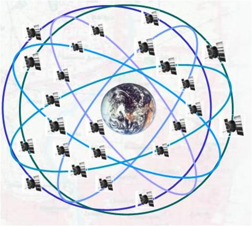
Fig: Space Segment
Control segment:
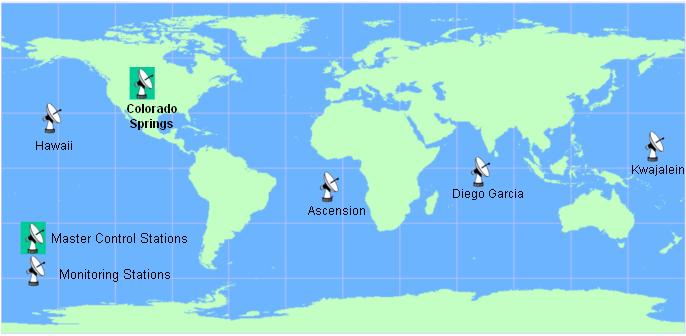
- Control segment consists of a group of 5 ground based monitor stations, three antennas and a master control station.
- The Master Control facility is located at Schriever Air Force Base (formerly Falcon AFB) in Colorado.
- The monitor stations measure signals from the SVs continuously and provides data to the master control station.
- The master control station calculates satellite ephemeris and clock correction coefficients and forwards them to an antenna.
- The antenna transmit the data to each satellite at least once a day. The SVs then send subsets of the orbital ephemeris to GPS receivers over radio signals
User segment:
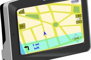
- GPS User Segment consists of the GPS receivers and the user community.
- The typical receiver is composed of an antenna and pre-amplifier, radio signal microprocessor, control and display device, data recording unit, and power supply.
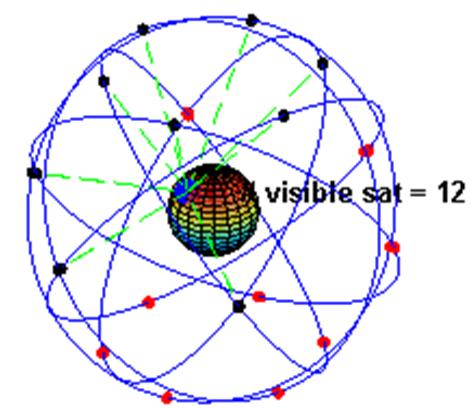
- GPS receivers convert SV signals into position, velocity, and time estimates. A minimum of four satellites are required to compute the four dimensions of X, Y, Z (position) and Time.
GPS Working Mechanism
Each of the 24 satellites emits signals to receivers that determine their location or range by computing the difference between the time that a signal is sent and the time it is received. The signal contains data that a receiver uses to compute the locations of the satellites and to make other adjustments needed for accurate positioning.
The receiver must account for propagation delays or decreases in the signal's speed caused by the ionosphere and the troposphere. GPS satellites carry atomic clocks that provide extremely accurate time. The time information is placed in the codes broadcast by the satellite so that a receiver can continuously determine the time the signal was broadcast. With information about the ranges of three satellites and the location of the satellite when the signal was sent, the receiver can compute its own three-dimensional position. An atomic clock synchronized to GPS is required in order to compute ranges from these three signals. However, by taking a measurement from a fourth satellite, the receiver avoids the need for an atomic clock. Thus, the receiver uses four satellites to compute latitude, longitude, altitude, and time.
How GPS Works
GPS, which stands for Global Positioning System, is a satellite-based navigation system that allows users to determine their precise location anywhere on Earth. The working mechanism of GPS involves a network of satellites, ground-based control stations, and GPS receivers. Here's an overview of how GPS works:
1. Satellite Constellation:
GPS relies on a constellation of satellites orbiting the Earth. The GPS satellite constellation consists of multiple satellites, typically around 24, spread across six orbital planes. These satellites are in Medium Earth Orbit (MEO), approximately 20,200 kilometers (12,550 miles) above the Earth's surface.
2. Trilateration:
The fundamental principle behind GPS is trilateration. Trilateration is a method of determining positions based on the distances between known points. In GPS, the known points are the GPS satellites, and the distances are determined using the time it takes for signals to travel from the satellites to the receiver.
3. GPS Signals:
Each GPS satellite continuously broadcasts signals that contain information about the satellite's position, time, and other data. These signals are transmitted in two frequencies: L1 (1575.42 MHz) and L2 (1227.60 MHz). The signals travel at the speed of light.
4. GPS Receiver:
To determine its position, a GPS receiver needs to receive signals from multiple satellites simultaneously. The receiver collects the signals from visible satellites in its line of sight. The receiver extracts the precise timing information from the signals.
5. Distance Calculation:
By comparing the arrival times of the signals from multiple satellites, the GPS receiver can calculate the distance between itself and each satellite. This is done by multiplying the time difference between the signal transmission and reception by the speed of light.
6. Position Calculation:
Once the receiver has obtained the distance measurements from at least four satellites, it uses the trilateration principle to calculate its precise position. The receiver uses the known positions of the satellites and the measured distances to determine its own latitude, longitude, and altitude.
7. Error Correction:
GPS signals can be affected by various sources of error, such as atmospheric delays, clock errors, and signal interference. To improve accuracy, GPS receivers use techniques like Differential GPS (DGPS) or Real-Time Kinematics (RTK) to correct these errors. DGPS uses a stationary reference station to transmit correction data to the GPS receiver, while RTK uses a base station and rover receiver to provide centimeter-level accuracy in real time.
By receiving signals from multiple satellites and performing trilateration calculations, GPS receivers can determine the user's precise location. GPS has become an essential technology for navigation, mapping, surveying, timing synchronization, and numerous other applications across various industries and everyday life.
MEASUREMENTS OF DISTANCE:
- Satellites broadcast radio signals (EM radiation)
- Simple distance calculation d = v * t
- Velocity = velocity of light 186,000 miles per seconds
- time is known (difference between send & receive)
- distance is calculated