Corrections for Baseline Measurement
Correction for sag is the deference in length between the are and its chord i.e b/t the curved length of the laps and the distance between the supports. It’s us required only when the tape is suspended during measurement.How to do Triangulation Survey
The line of sight should not be near the surface of ground at pt of tangency on account of strata of disturbed air and should be kept at least 2m (61) above the ground preferably 3m (1D) and this allowance (clearance) should be made in deterring the heights of stations. If the peaks in the intervening ground are likely to obstruct, the line of sight, their elevations and
How to do Trigonometric Surveying
Geodetic or trigonometrically surveying takes into account the curvature of earth Since very extensive areas and very large distances are involved. In geodetic surveying highly refined instruments and methods are used. Geodetic work is undertaken by the state agency e.g. survey of Pakistan undertaken by the state agency. The object of geodetic surveying is to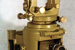
What is Phototheodolite - Working Principle, Components & Applications
A photo theodolite is a form of ground camera. It is a combination of camera and theodolite ans is used of taking photographic and measuring the angles which the rival plane of collimation makes with base line. The optical axis of the camera is arrange parallel to the line of collimation of the chocolate telescope and the theologize allows The determination of the orientationWhat is Trilateration Surveying
Because of the development of highly accurate electronic measuring devices, a triangulation system can be completely observed, computed and adjusted by measuring the lengths o the sides in the network.Applications of Triangulation
The establishment of accurately located control points for surveys of large. The accurate location of indirection work such as: Centre lines, terminal pts shafts for long tunnelsClassification of Triangulation System
Triangulation system may be classified according to Degree of accuracy required Magnitude of workTypes & Uses of Photographic Surveying
Photographic surveying also called photograph icing is a method of surveying in which plans or maps are prepared from photographic taken at suitable camera stations or photographic is the science of making measurement from photographs. In terrestrial photo-grammetry maps are prepared from terrestrial (or ground) photographs or terrestrialHydrographic Surveying - Objectives and Uses of Hydrographic Surveying
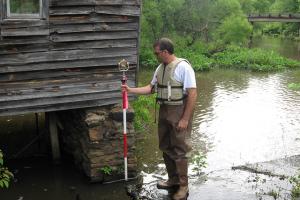
It is the branch of surveying which deals with any body of still or running water such as a lake, harbor, stream or river. Hydrographic surveys are used to define shore line and under water features. Hydro-graphic surveying are carried out for one or more of the following activities.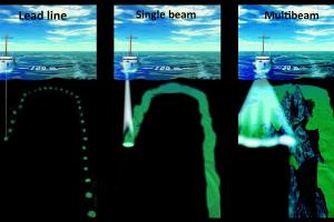
Method of Surveying a River & Sounding
The survey of the shore line of a river is made by running a theodolite and tape traverse on a shore at a convenient distance form the edge of the water. If the river is narrow, a single theodolite and tape traverse is on one bank and both banks. Located by staid or plane table methods. If the river is wide, it is necessary to run traverses on both banks and locate each shore