Method of Surveying a River & Sounding

The survey of the shore line of a river is made by running a theodolite and tape traverse on a shore at a convenient distance form the edge of the water. If the river is narrow, a single theodolite and tape traverse is on one bank and both banks. Located by staid or plane table methods.
If the river is wide, it is necessary to run traverses on both banks and locate each shore line by staid or plane tabling form its traverse. For checking purposes, the two traverses should be tide to each other at intervals by cross-bearing or angles.
-
Station B and C are connected to B and C
-
Measure < B/BC and < C/BC
-
Measure < BCB/ and < BCC/
-
Form these angles and measured length of BC, B/C/ may be competed
-
In this is in close agreement with measured length of B/C/ the fig is completely cheeked. If the river is too much crooked, it is not necessary to follow it closely by the traverse may be run in most favorable location and subsidiary traverse is run around the bank to locate the necessary detail
When the shore lines of rivers and lakes are obstructed by woods, it is not economical to locate it by traversing. It is required to use a sys of triangulation. As a check upon the survey a base line is measured at the end of the survey and also additional check bases are measured at intervals of 10-15miles.
AB = Base line C, D, E, F, --------- are trigonometric stations

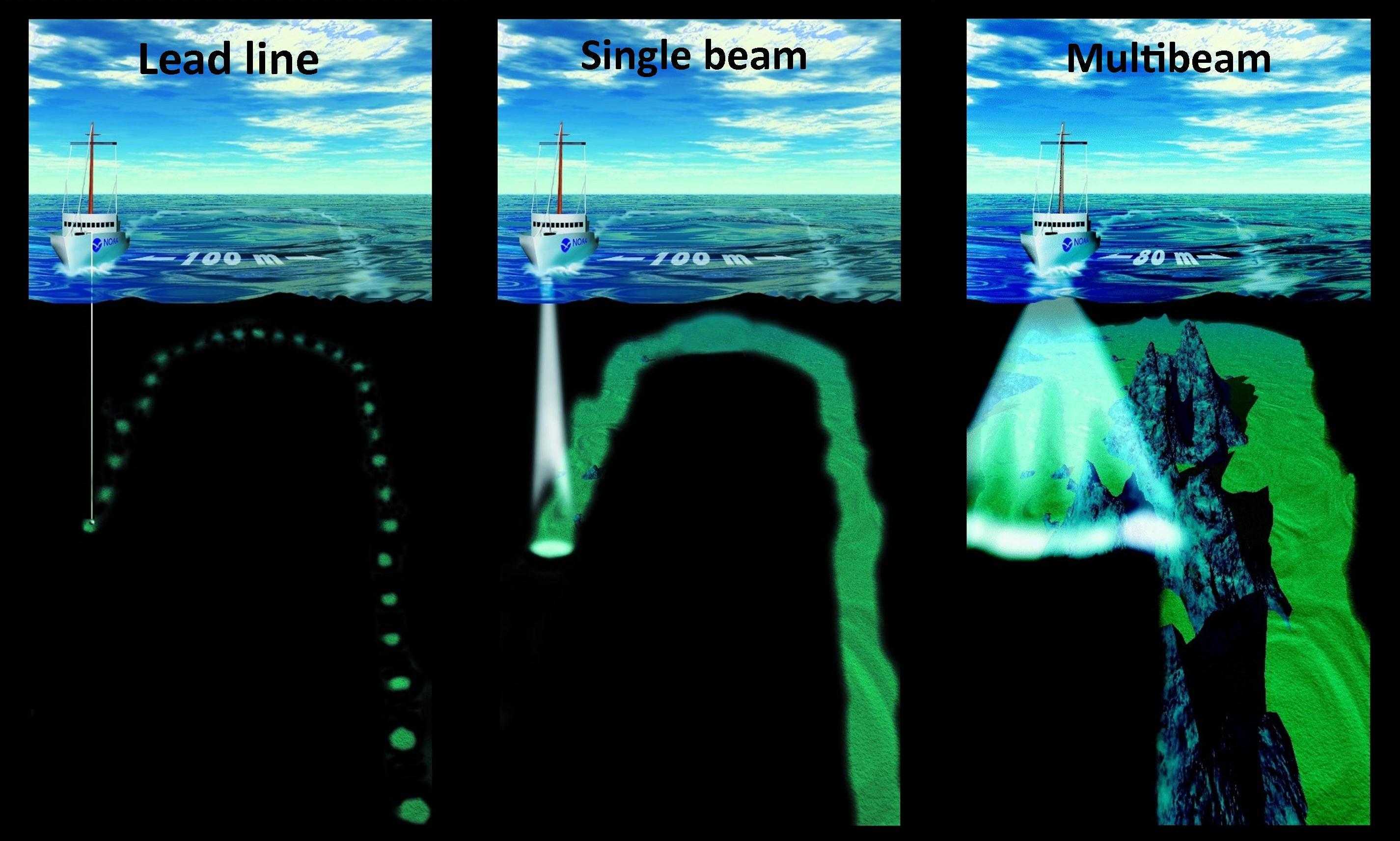
Soundings in Surveying
1. Definition
The measurements of depths below the water surface are called Sounding.
2. Objective of sounding:
The object of making soundings is to determine the configuration of the bottom of the body of water. This is done by measuring form the boat, the depth of water at various points.
3. Uses and Applications of Soundings
- The preparation of charts for navigation.
- The determination of the quantity of the material dredged and of area. Where the material is to be dredged or the dredged material may be dumped.
- The design of works such as brick water, sea walls etc
4. Guages:
The guages may be divided in to two classes.
- Non Self Registering
- Self Registering
An observer is req to read oneself registering gage while the self registering gauge is automatic and is generally used when accurate and continuous record of fluctuations the water surface is required.
4.1.1 Types of Non-Self Registering gages
- Staff gage
- Float gage
- Chain or weight gauge
The gauge should be established at a convenient place where it is unaffected by the action of waves and is protected for storms.
5. Equipment for making Sounding:
5.1 Sounding Boat
It should be sufficiently roomy and stable. Flat bottomed boat is suitable in quite water is round bottomed boat is convenient in rough water. A power boat (steam or motor aunch) is most suitable when wind is blowing and the water currents are strong.
5.2 Sounding Rods or Poles
Sounding rods or poles are convenient in shallow and smooth water up to depths of about 4 to 6 m (15-20ft). they are made of well-seasoned timber and are auricular in section of abut 5cm(2//) diameter and 3 to 7.5m long (12-25) graduated in meter or centimeter (ft or inches) with a metal shoe at the bottom.
5.2.1 Purposes:
Direct depth measurements are taken by lowering it vertically into the H2O until it hits the bottom and reading the graduation at the surface.
5.3 Lead Lines:
The lead lines also called sounding lines are used for depth over 6m (20/). It consist of a suitable length of stretch-resistant cord or other material to which a heavy lead weight (5 to 10) is attached. The cord is make with feet or meter graduations and these should be checked frequently against an steel tape fro their accuracy.
Use: In use the weigh is lowered into the water being careful to keep the cord vertical. The graduation at the surface is read when the weight hits the bottom.
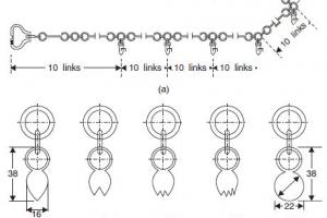
5.4 Sounding Chain:
For regular sounding a brass such-chin is most satisfactory since its length is practically const i.e, the links are welded. The brass tags are attached at 0.2m (1') interval but leather or cloth tags are preferred as the brass tags can injure the hands of the surveyor. The chain should be tested periodically.
5.5 Sounding Lead:
The attached to a lead line is conical in shape and very strong, (2.5-12.5) kg (5-25lbs) depending upon the depth of water current
-
- For shallow still water the wt is 2.5kg (5lbs)
- Moderate depth up to 10m (40') wt is 5kg (10bs) fairly quiet water.
- Greater depth where corrects are strong wt = 10kg
The wt is circular in cross-section and length equal to 3 to 4 times the diameter and slightly tapers towards the top end.
5.6 Fathometer:
For ocean sounding an insert. Known as fathometer is used. It is electric device and measure the time required for the sound (impulses) travel to the bottom of water and back. The travel time is converted into depth displayed in either digital or graphic for fathometer is also called echo sourer.
5.7 Sounding Machine:
It is very use full much sounding is to be done. The type commonly used is hand driven and consists
- A point wire carrying a 7kg (14lbs) load wound around a drum.
- Two dials the outer one indicating the depth in meter or feet and the inner one in cm or inches, connection to a drum by means of gears. It is mounted in a sounding boat and can be used up to a maximum depth of 30m (100')
5.8 Sextant:
The theodolite and other instrument used in land surveys are not used in a boat where the support is unstable. The sextant is well suited to hydro graphic work and has the added advantage of measuring angles in any plane. It is the most precise hand instrument yet device for measuring angles. There are two versions of the instruments
- Nautical sextant (or sounding sextant)
- Box sextant.
5.9 Signals:
Shore signals are required to mark the ranges i.e, lines along which sounding are to taken and the reference points to which angular observations are to be taken from the boat. They should be clearly visible for considerable distances. If the water is shallow, ordinary pole signal may be used but if water deep buoys are used as signals.
5.10 Ranges:
The lines on which sounding are taken are called ranges or range lines. They are laid on the shore parallel to each other and at right angles to the shore line or radiating form a prom nay natural object when the shore line is very irregular.
Each range line should be marked by means of signals erected at 2 points it, at considerable distance apart. The spacing of range lines vary form 6m 30m (20 to 100ft) depending upon the object of survey and the nature of the bottom.
6. Making the Soundings:
- Up to depths of 20m (75/), the sounding are made while the boat is in motion.
- If the sounding is made by the sound rods, the leads man stands in the bow plunges it in forward direction fro enough that when it reaches the bottom, it will in vertical position. He then reads the quickly and calls out the observed reading of each sounding to the recorder who it and records it as well as the no time of the sounding.
- The nature of bottom is observed and at intervals in the note book.
- When the sounding line is used, the leading plunges the lead forward at such a that the line will become vertical at point where the sounding is to be taken when leads reaches the bottom.
- If the water is very deep and still, sounding, are taken by stopping the boat for each sounding.
- For ordinary engineering purposes sounding are taken at 8-15m intervals (25-50/) but for special purposes they may be taken at as close as 2 to 3m (10/) intervals.
7. Methods of Locating Soundings:
Soundings may be located by the following methods which are commonly used
- By transit and staid
- By range and time intervals
- By range and one angle form shore
- By range and one angel form boat
- By two angle storm shore
- By two angles form boat
- By intersecting ranges
- By cross rope
- By distances along a wire or rope stretched a crossed a stream b/w stations.
7.1 Location by Range & One Angle from Shore:
In this method the positions of sounding are located by measuring two angles simultaneously with a sextant, from the boat (P) to three shore signals or any points (A, B, and C) whose positions have been previously known.
The points sighted should be well defined such as chimneys, light houses etc. In order to minimize the error in measuring the angles and plotting them, the nearer object should be proffered to distant one. This method is commonly used where to range are employed.

7.2 Location by distance along a wire or rope, stretched acrossed stream between stations:
In this method a wire or rope is stretched b/w fixed points on opposite banks and is marked by means of cloth or metal tag, at equal intervals along the rope or wire. The boat is rowed to these points and sounding are taken. This is most accurate but most expensive method. It is used when sounding are to be taken along the cross-section of a canal or narrow river. It is also used when it is required to determine the quality of material removed by dredging. The soundings are taken b/t and after dredging work is done.
7.2.1 Disadvantages:
- It is unsuitable for situations where the operations are subjected to sudden interruption by shipping
- The action of winds and current on the float increases the lateral sag