Chain Survey Steps - Method for Performing Chain Surveying

Definition
A chain survey is the simplest method of surveying. In this survey, only measurements are taken in the field, and the rest work, such as plotting calculation, etc. are done in the office. This is most suitable adapted to small plane areas with very few details. If carefully done, it gives quite accurate results. The necessary requirements for field work are chain, tape, ranging rod, arrows and sometimes cross staff.
- It is a system of surveying in which sides of various triangles are measured directly in the field and NO angular measurements are taken.
- It is the simplest kind of Surveying
- It is adopted when the Level of accuracy required is not high.
Also See: Types of Surveying Chains
Chain survey steps:
Chain surveying is a traditional method of land surveying that involves measuring distances and angles using a chain or a tape measure. It's worth noting that the chain survey method has limitations, particularly in terms of accuracy and efficiency compared to modern surveying techniques. However, it is still used in certain applications or areas where the terrain or project requirements make it a suitable option. Here are the typical steps involved in conducting a chain survey:
1. Reconnaissance
The preliminary inspection of the area to be chain surveyed is called reconnaissance. The surveyor inspects the area to be surveyed, survey or prepares index sketch or key plan. Walk the whole area and thoroughly examine the ground, note the position of boundaries, road, and river etc., various difficulties to chain lines, select stations, and prepare neat sketches called index sketches or key plan. Begin by conducting a preliminary survey of the area to gather information about the terrain, boundaries, and any existing survey markers or control points. This helps in planning the survey and determining the most suitable chain lines.
2. Marking stations
Stations are marked with ranging rod, or wooden peg, driving a nail or spikes if hard surface, or embedding stone with a cross mark. Mark the survey points or features using permanent markers such as stakes, nails, or monuments. These markers help in identifying and locating the points during subsequent surveys or when establishing boundaries. Set up a starting point or a reference station at a known location in the survey area. This can be a prominent feature, an existing survey marker, or an arbitrarily chosen point. Mark the station with a permanent marker or a temporary flag for reference.
3. Reference sketches
After marking the station should be referenced i.e. located by measurement called ties taken from 3 permanent points which are easily identified such as corner of building.
4. Running survey line
After the preliminary work, chaining is started from base line and carried throughout all the line of the framework continuously. So chain is laid and kept lying, offset are taken to locate the nearby details. Make ranging wherever necessary. Measure the change and offset and enter in the field book. Select a chain line, which is a straight line that connects survey points or features of interest. Measure the length of the chain line using a chain or tape measure. Repeat this process for all the required chain lines in the survey area.
5. Angle Measurement:
Determine the angles at each survey point using a compass or a theodolite. Set up the instrument at the reference station and sight to the next station, noting the angle of the line relative to a reference direction, such as north.
6. Offsets and Detail Measurements:
Conduct offset measurements from the chain line to capture additional details such as boundaries, structures, or other features of interest. Use perpendicular measurements from the chain line to mark the positions of these features.
7. Note Keeping:
Record all measurements, angles, offsets, and other relevant data in a field notebook or survey record book. This includes details of the chain line, angles, and any observations or relevant information about the survey points or features.
8. Closing the Survey:
To ensure accuracy and reliability, close the survey by returning to the starting point or reference station. Measure the distance and angle from the last station to the reference station to verify the closure of the survey. The closure should ideally result in a small or negligible error.
9. Calculation and Plotting:
Back in the office, calculate the coordinates or positions of the surveyed points using trigonometric calculations based on the measured distances and angles. Plot the surveyed points on a map or plan, representing the topography or boundaries of the survey area.
Chain Survey is Suitable when:
- The ground is fairly level and simple
- Plans are required on a large scale e.g. fields
- When the area is small in extent
Chain Surveying is Not Suitable
- For Large Areas
- When too many details are required
- Wooded countries
- Undulating areas
Since the triangle is a simple plane geometrical figure, it can be plotted from the measured length of its sides alone; therefore, the principle of chain survey is Triangulation. In chain surveying, a Network Triangle is preferred. Preferably all the sides of a triangle should be nearly equal having each angle nearly 60 to ensure minimum distortion due to errors in measurement of sides and plotting. Generally such an ideal condition is not practical always. Usually attempt should be made to have WELL-CONDITIONED TRIANGLES in which no angle is smaller than 30 and no angle is greater than 120.
Procedure to Measure Area by Chain Triangulation in Chain Survey
Procedure:
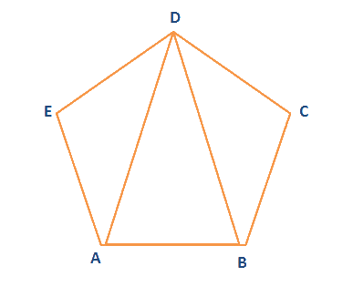
- Let ABCDE be the given field whose area is to be measured, and fix the pegs at A, B, C, D & E.
- Divide the area into three triangles ADE, ABD, and BCD by joining AD and BD.
- Measure the lengths AB, BC, CD, DE, EA, AD, and BD.
- Calculate the area of the triangles.
- The sum of the areas of the three triangles is the area of the given field.
![]()
![]()
Result:
The area of the given field = _______
Survey Station:
Survey stations are of two kinds:
- Main Stations
- Subsidiary or tie
Main Stations:
The main stations are the end of the lines, which command the boundaries of the survey, and the lines joining the main stations are called the main survey line or the chain lines.
Subsidiary or the tie stations:
Subsidiary or tie stations are the points selected on the main survey lines, where it is necessary to locate the interior detail such as fences, hedges, buildings, etc.
Tie or subsidiary lines:
A tie line joints two fixed points on the main survey lines. It helps to check the accuracy of surveying and to locate the interior details. The position of each tie line should be close to some features, such as paths, buildings, etc.
Base Lines:
The baseline is the main and longest line, which passes approximately through the center of the field. All the other measurements to show the details of the work are taken with respect of this line.
Check Line:
A check line also termed as a proof line is a line joining the apex of a triangle to some fixed points on any two sides of a triangle. A check line is measured to check the accuracy of the framework. The length of a check line, as measured on the ground should agree with its length on the plan.
Offsets:
These are the lateral measurements from the base line to fix the positions of the different objects of the work with respect to base line. These are generally set at right-angle offsets. It can also be drawn with the help of tape. There are two kinds of offsets:
- Perpendicular offsets
- Oblique offsets
The measurements are taken at a right angle to the survey line called perpendicular or right-angled offsets. The measurements which are not made at right angles to the survey line are called oblique offsets or tie line offsets.