Direction Measuring Equipment in Surveying

There are two major techniques for measuring direction. These are:
- By means of compasses
- By celestial observation
Compasses:
Two needle- types are used:
-
Box compasses and
-
Circular compasses
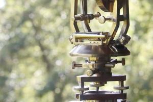
Box compasses must be used with angle – measuring instruments, as the compasses operate only when the line of sight points towards magnetic north. The bearing desired must then be measured from his direction. Circular compasses can be mounted on theodolites and are often permanently mounted on transits. When provided with open sights, they can be used alone, either mounted on light tripod or held in the hand.
Magnetic declination, called variation by mariners, is the angle from the direction of true north to the direction of the needle. This angle varies from place to place and at any place, it changes slowly through large, little understood swings. This is called secular change. The diurnal change is more or less regular swing as follows:
Quiescent at its means position from 9pm – 3am, then easterly to 2-5 minutes at 8 or 9 am, and then westerly to 2-5 minutes at 1 or 2 pm and to the mean at 9pm . There is also an annual swing in the order of one minute, varying according to locality.
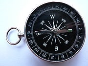
A simple dry magnetic pocket compass
Celestial Observation:
Surveying north or astronomic north, the direction of celestial North Pole is determined by observation of the sun and stars with transits or theodolites. The most accurate method of determining direction is to observe the North Star (Polaris) in latitudes where it is visible and not too high to give accurate results. In southern latitudes, there are six bright stars about 30o from the pole, well distributed so that one is usually above the horizon. These are observed in the same way as Polaris.
As the first step, the horizontal direction of star is measured for a mark on the ground. The precise time is recorded at the moment the instrument is pointed at the star. With relation to the earth station can be computed. If any of these data is unavailable, further observations are required.
The second method is sometimes used. The altitude, direction and the time of observation are noted for a star in the east and one in the west at about the same elevation. By referring to astronomical tables, the resulting bearings of the mark are obtained. These are averages and thus observational errors in the vertical angles are reduced.