Video on Method of Terrestrial Photogrammetry
The principal is exactly similar to plan table surveying, it may be stated as “The position of the object with ref to the base line is given by the intersection of the rays drawn to it form each end of the base line” In plane tabling most of the work is executed in the field while in this method it is done in the office.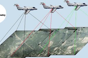
Principal Method of Terrestrial Photogrammetry
The principal is exactly similar to plan table surveying, it may be stated as “The position of the object with ref to the base line is given by the intersection of the rays drawn to it form each end of the base line” In plane tabling most of the work is executed in the field while in this method it is done in the office. The principal is explained as follows: C and D = Camera
Factors Affecting Selection of Highway Location
Traffic planner from various studies can predict the effect of travel patterns of alternative location proposed highway. Also they analyze the probable effect of new links in highway network. This permits the location engineer to determine how well alternative locations will fit with the existing network. Lanuse is a major factor affecting the pattern of trafficEquipment and Advantages of Aerial Photography
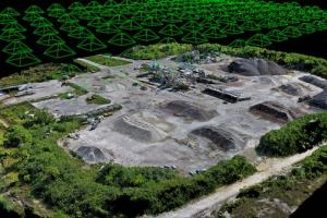
Arial photogram try induces the use of photographs taken in a systematic manner from the air they are then controlled by lend survey and measured by photogrametric techniques. Since the First World War the terrestrial photographic surveying has been replaced by aerial photographic surveying or aerial surveying for most of survey work due to development of aero plane.Types of and Uses of Photographic Surveying
Verticals are taken with the axis of the camera pointing vertically downward. These photographs can produce more accurate maps as the variation n scale over the area is smaller and no area remains hidden. However the details in photograph can not be easily identified as the view offered is unfamiliar to eyes. Oblique are produced by giving a camera a tilt up to 30 to theAngle Measuring Equipment in Surveying
The theodolite is the basic instrument for measuring horizontal and vertical angles. It consists essentially of a sighting tube in form of a telescope, an horizontal and vertical scales, which are so set that horizontal and vertical angles of the object sighted in the telescope can be read from the scale (see fig. 5 and 6)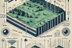
Scale and Distortion of a Vertical Photograph
The scale of the photograph is expressed as a representative fraction. (A scale having the importance that we can take it in any unit). Knowing the height of the airplanes above the datum and the focal length of the camera.
