What is Phototheodolite - Working Principle, Components & Applications

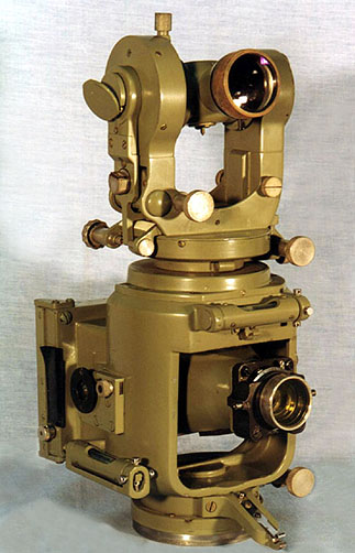
In the realm of geospatial surveying and photogrammetry, the phototheodolite has emerged as a powerful instrument combining the functionalities of a theodolite and a camera. This advanced optical instrument has found extensive applications in various fields, such as cartography, civil engineering, urban planning, and environmental monitoring. In this article, we will delve into the details of the phototheodolite, exploring its components, working principle, and the diverse applications that have made it an indispensable tool for professionals. A photo theodolite is a form of ground camera. It is a combination of camera and theodolite and is used for taking photographs and measuring the angles which the rival plane of collimation makes with base line. Both the theodolite and the camera rotate about a common vertical axis. The instrument is used for terrestrial photogrammetry
It should be noted that the pointing of the theodolite is completely independent of that of the camera, but the horizontal circle, which is located on the top of the camera housing, is fixed in such a way that when the circle reading is zero, the optical axes of the theodolite and camera lie in the same vertical plane. This means that all horizontal directions observed with the theodolite can be easily related to the principal point of the photograph.
Understanding the Phototheodolite:
The phototheodolite is a sophisticated device that combines the principles of theodolite measurements with the ability to capture accurate photographs. It consists of a theodolite — an instrument used for precise angle and azimuth measurements — integrated with a high-quality camera. The instrument is typically mounted on a sturdy tripod and incorporates specialized features to ensure precise alignment and image capture.
Working Principle of the Photo Theodolite:
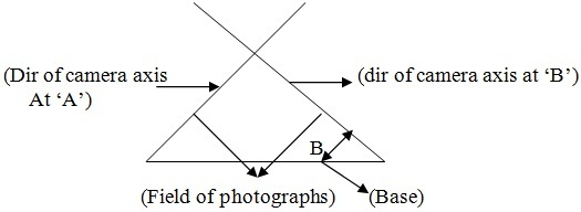
The phototheodolite operates based on the principle of triangulation. It utilizes a combination of precise angle measurements and optical observations to determine the three-dimensional coordinates of a target object. The instrument records both the horizontal and vertical angles to the target, along with the camera's optical axis. By capturing photographs of the target from different orientations, it allows for the calculation of accurate spatial positions.
Components and Features of a Photo-Theodolite:
Telescope:
The photo-theodolite is equipped with a high-quality telescope that enables precise angle measurements. It offers adjustable magnification and focus for clear and accurate targeting.
Camera:
The integrated camera is a crucial component of the photo theodolite. It is designed to capture high-resolution images of the target object, ensuring a comprehensive and accurate representation of the surveyed area.
Angular Measurement System: The instrument incorporates a highly sensitive angular measurement system, consisting of a horizontal and vertical circle, which allows for precise angle measurements.
Reticule:
The reticule, placed inside the telescope, aids in targeting and aligning the instrument accurately on the desired point.
Data Storage and Processing:
Modern phototheodolites often include built-in storage and data processing capabilities, enabling efficient data management and analysis.
Applications of Phototheodolite
Topographic Mapping:
The phototheodolite plays a vital role in creating accurate topographic maps by capturing overlapping aerial photographs. These images are processed using photogrammetric techniques to generate three-dimensional models of the terrain, helping in urban planning, land development, and infrastructure design.
Construction and Engineering Surveys:
The instrument aids in monitoring and controlling construction projects by accurately measuring the positions and elevations of various project elements. It enables efficient stakeout of buildings, roads, bridges, and other structures.
Photogrammetry:
Photo-theodolite is extensively used in photogrammetric surveys to create orthophotos and digital surface models. These outputs serve as valuable resources for applications such as environmental monitoring, landscape analysis, and disaster management.
Archaeology and Cultural Heritage:
The photo theodolite contributes to the preservation and documentation of archaeological sites and cultural heritage. Capturing detailed images and precise measurements enables the creation of accurate digital representations for research and restoration purposes.
Geodetic Surveys:
Photo theodolites are employed in geodetic surveys for accurate positioning and alignment of reference points in global positioning systems (GPS). They play a crucial role in establishing control networks and geodetic datums.
The phototheodolite has revolutionized the field of surveying and imaging, providing professionals with a powerful tool for accurate measurements and high-resolution photography. Its ability to combine the functionalities of a theodolite and a camera has enabled significant advancements in various domains, ranging from topographic mapping to archaeology. As technology continues to evolve, photo theodolites are likely to become even more precise, efficient, and versatile, further expanding their applications in the geospatial industry.