ACI Building Code Requirements and Safety Provisions
Structural members must always be proportioned to resist loads greater than service or actual loads, in order to provide proper safety against failure. In the strength design method, the member is designed to resist the factored loads which are obtained by multiplying the factored loads with live loads. Different factors are used for different loadings. As dead loads can be estimated
Concrete Accelerators - Definition, Examples and Effects
Accelerating Admixture - an admixture that causes an increase in the rate of hydration of the hydraulic cement and thus shortens the time of setting, increases the rate of strength development, or both. Accelerating admixtures are added to concrete either to increase the rate of early strength development or to shorten the time of setting, or both. ChemicalFrame Design and Analysis using SAP2000
3D Frame Analysis using SAP2000 Watch Videos on How to design a 3D Frame - Part 1 | Part 2 in SAP2000Traffic Load - Definition and Analysis
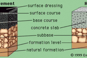
This is the role of the Pavement Engineer and involves determining the loading on the road to be carried forward to the Pavement Design. The role of the pavement engineer is to provide an adequate thickness of pavement to carry the expected loads without deterioration of the network during the design life. The estimated or projected magnitude and occurrence of
Highway Drainage Design, Structures and Guidelines
Includes collecting, transporting, and disposing of surface/subsurface water originating on or near the highway right of way or flowing in streams crossing bordering that right of way. Drainage of highway is important because water damage highway structure in many ways. The water which are dangerous for highways are: Rainwater: Cause erosion on surface or mayBaseline Measurement and Equipments Used
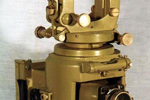
In triangulation the base line is of prime importance because it is the only horizontal distance to be measured. It should be measured very accurately since the accuracy of the computed sides of triangulation system depends on it.Corrections for Baseline Measurement
Correction for sag is the deference in length between the are and its chord i.e b/t the curved length of the laps and the distance between the supports. It’s us required only when the tape is suspended during measurement.How to do Triangulation Survey
The line of sight should not be near the surface of ground at pt of tangency on account of strata of disturbed air and should be kept at least 2m (61) above the ground preferably 3m (1D) and this allowance (clearance) should be made in deterring the heights of stations. If the peaks in the intervening ground are likely to obstruct, the line of sight, their elevations and
How to do Trigonometric Surveying
Geodetic or trigonometrically surveying takes into account the curvature of earth Since very extensive areas and very large distances are involved. In geodetic surveying highly refined instruments and methods are used. Geodetic work is undertaken by the state agency e.g. survey of Pakistan undertaken by the state agency. The object of geodetic surveying is to