How to Measure Rainfall / Precipitation

All the forms of precipitation are measure on the basis of vertical depth of water that would accumulate on a level surface of precipitation remained where it fell. In metric system precipitation is measure in millimeters and tenths. Any open receptacle with vertical side can be used as a gauges for measuring rainfall. These refined receptacles with vertical side can be used as a gauges for measuring rainfall.
Rain gauges for measurement of precipitation are of two types
- Recording rain gauges
- Non-Recording rain gauges
1. Non-recording rain gauges:
Non-recording rain gauges are commonly used. They do not record the data and collect only rain and this collected rain is then measured in a graduated cylinder.
Depth of rain = volume of rain collected in cm3/area of aperture of gauges in cm3
This type of gauges measures precipitation for only a specified period. Any open receptacle with vertical sides may be used for precipitation measurement but because of varying wind and splashing effect. The measurements are not compatible unless the receptacles of same size, shape and exposed in a similar manner. The US national weather service gauges is type of non recording gauges.
It consists of:
- Collector (receiving 8" 20.3 cm diameter)
- Overflow can
- Cylindrical measuring tube of area of 1/19th of collector
- Measuring scale
Measuring tube is placed in overflow can and with measuring sticks; the depth of rainfall can be measured. As area of M-Tube is 1/10th of collector, therefore 1" depth of rain in M-Tube corresponding to 0.1" of rainfall. In case of snow the M-Tube and the collectors are removed and the snow is collected, melted and poured in M-Tube and measured.
2. Recording gauges:
Are those which automatically record rainfall without any bottle reading. The worker is not required to record the reading but instead mechanical arrangements are there by which total rainfall is recorded automatically on graph paper. A graph of total rainfall VS time which is known as mass curve of rainfall is plotted by the gauges.
Its three types commonly used are:
- Tipping bucket gauges
- Weighing type gauges
- Float recording gauges
1. Tipping bucket gauges:
In TBG the collector is funneled into two compartment buckets. When one compartment of bucket is filled with rain water it becomes over balanced and tips such that the other compartment takes its place beneath the funnel.
As the bucket is tipped it automatically activates an electronic circuit. This type of gauges is not suitable for measuring snow (without heating the collector).
2. Weighing type gauges:
It consists of a storage bin, which is weighed to record the mass. It weighs rain or snow which falls into a bucket, set on a platform with a spring or lever balance. The increasing weight of the bucket and its contents are recorded on a chart. The record shows accumulation of precipitation.
3. Float recording gauges:
The rise of float with increasing catch of rainfall is recorded. Some gauges must be emptied manually while others are emptied automatically using self starting siphons. In most gauges oil or mercury is the float and is placed in the receiver, but in some cases the receiver rests on a bath of oil or mercury and the float measures the rise of oil or mercury displaced by the increasing weight of the receiver as the rainfall catch freezes. Float may get damaged by rainfall catch freezer. Storage gauges are used in remote areas where frequent servicing is not possible. Weighing type storage gauges operate for 1 or 2 months without any servicing required.
Weighing type storage gauges are designed to operate for entire season without attention. WTSG located in heavy snowfall areas should have collectors to prevent wet snow from clinging to the inside of walls and clogging the orifice. The orifice should be above the maximum snow depth expected. Gauges are initially dry and require moisture for funnel and inside surfaces. During rainfall of 5" to 6"/hr (12.5 to 250 mm/hr) the bucket of tipping bucket gauges tips every 6 to 7 seconds and takes about 0.3 seconds to complete the tipping procedure, during which some water is still pouring into already filled compartments. The recorded ratio is 5% too low.
- Error caused by wind in gauges reading
- When gauges are installed on the ground, it is inclined against the wind and thus catches less precipitation. Towards the wind it will catch more precipitation.
- Obstruction due to trees, buildings and un-even topography.
Snowfall measurement:
Snowfall is often measured with regular rain gauges. Snowfall is measured by the depth of snow using snow survey. Such survey is particularly useful in mountains.
Installation of gauges
While installing rain gauges following points should be kept in mind.
- Flatter ground
- Avoid steep hill side
- Avoid sloping down towards prevailing wind
- Site should not be too closed to building or forested area.
- All obstruction should be avoided.
- Interpretation of precipitation
Estimation of Missing Precipitation Data
This situation will arise if data for rain gauges are missing (e.g. due to instrument failure). Data from surrounding gauges are used to estimate the missing data. Three approaches are used:
Arithmetic mean:
Use when normal annual precipitation is within 10% of the gauge for which data are being reconstructed
Where:
Pm = precipitation at the missing location
Pi = precipitation at index station I
N = number of rain gauges
The Normal ratio method:
Normal ratio method (NRM) is used when the normal annual precipitation at any of the index station differs from that of the interpolation station by more than 10%. In this method, the precipitation amounts at the index stations are weighted by the ratios of their normal annual precipitation data in a relationship of the form:

Where:
Pm = precipitation at the missing location
Pi = precipitation at index station
Nm = average annual rain at ‘missing data’ gauge
Ni = average annual rain at gauge
N = number of rain gauges
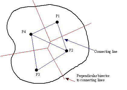
Reciprocal Inverse Weighting Factor Approach
Procedure:
- Divide area around gauge of interest into four quadrants
- Using records at nearest station in each quadrant
- Compute missing precipitation amount:
Where:
Pi = rainfall recorded by gauge i
Xi = distance from gauge i to missing data point

Consistency of Precipitation Data
A double-mass curve is used to check the consistency of a rain gauge record:
- compute cumulative rainfall amounts for suspect gauge and check gauges
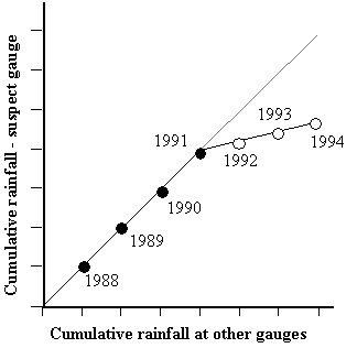
- plot cumulative rainfall amounts against each other (divergence from a straight line indicates error)
- multiplying erroneous data after change by a correction factor k where
![]()
Precipitation Analysis
- Areal precipitation estimation
- Depth-area analysis
- Precipitation frequency
- Intensity-duration analysis
- Intensity-duration- frequency analysis
Areal Precipitation Estimation
-
- Arithmetic mean method
- Thiessen method
- Isohyetal method
Arithmetic mean method
Theissen Method
- Divide the region (area A) into sub-regions centred about each rain gauge;
- Determine the area of each sub-region (Ai) and compute sub-region weightings (Wi) using: Wi = Ai/A
- Compute total aerial rainfall using
Isohyetal Method
Potentially most accurate approach, but subjective
- Plot gauge locations on a map;
- Subjectively interpolate between rain amounts between gauges at a selected interval;
- Connect points of equal rain depth to produce lines of equal rainfall amounts (isohyets);
- Compute aerial rain using:

Infiltration Indexes
- Infiltration index is the average rate of loss such that the volume of rainfall in excess of that rate will be equal to direct runoff.
- Estimates of runoff volume from large areas, having heterogeneous infiltration and rainfall characteristics, are made by use of infiltration indexes.
- Infiltration indexes assume that infiltration rate is constant throughout the storm duration. This assumption tends to underestimate the higher initial rate of infiltration while overestimating the lower final rate.
- Infiltration indexes are best suited for applications involving either long-duration storms or a catchment with high initial moisture content. Under such conditions, the neglect of the variation of infiltration rate with time generally justified on practical grounds.
- Two types of indexes: Phi-index and W-index are used.
Hydrologic Soil groups
All soils are classified into four hydrologic soil groups of distinct runoff-producing properties. These groups are labeled A, B, C and D. Following is the brief of their runoff and infiltration properties:
A Lowest runoff potential (Greater than0.03 in/hr)
B Moderately low runoff potential (0.15 – 0.30 in/hr)
C Moderately high runoff potential (0.05 – 0.15 in/hr)
D Highest runoff potential (0 – 0.05 in/hr)
Land use and Treatment
- The effect of the surface conditions of a watershed is evaluated by means of land use and treatment classes.
- Land use belongs to watershed cover, including every kind of vegetation, litter and mulch, fallow (bare soil), as well as nonagricultural uses such as water surfaces (lakes, swamps), impervious surfaces (roads, roof, and the like), and urban areas .
- Land treatment applies mainly to agricultural land uses, and it includes mechanical practices such as contouring or terracing and management practices such as grazing control and crop rotation.
- A class of land use/treatment is a combination often found in a literature.
Ground surface (Hydrologic) condition
Hydrologic condition is based on combination of factors that affect infiltration and runoff, including:
- Density and canopy of vegetative areas,
- Amount of year-round cover,
- Amount of grass or close-seed legumes in rotations,
- Percent of residue cover on the land surface
- Degree of roughness
Poor: Factors impair infiltration and tend to increase runoff
Good: Factors encourage average and better than average infiltration and tend to decrease runoff.